admin_bounds_gdf = gpd.read_file("../data/geoboundary.geojson")Spatial Join Highest Intersection
find intersection of largest area joined
![]()
Import
Generate Test Data
Load a sample admin boundary file using geopandas
admin_bounds_gdf.head(3)| shapeName | shapeISO | shapeID | shapeGroup | shapeType | geometry | |
|---|---|---|---|---|---|---|
| 0 | Abra | None | PHL-ADM2-3_0_0-B1 | PHL | ADM2 | MULTIPOLYGON (((120.96795 17.95706, 120.97803 ... |
| 1 | Agusan del Norte | None | PHL-ADM2-3_0_0-B2 | PHL | ADM2 | MULTIPOLYGON (((125.57724 9.45679, 125.59687 9... |
| 2 | Agusan del Sur | None | PHL-ADM2-3_0_0-B3 | PHL | ADM2 | MULTIPOLYGON (((125.91087 8.85625, 125.91461 8... |
admin_bounds_gdf.dtypesshapeName object
shapeISO object
shapeID object
shapeGroup object
shapeType object
geometry geometry
dtype: object# admin_bounds_gdf.explore()Generate a sample grid
grid_generator5k = grids.SquareGridGenerator(50_000) # 5 km x 5 km square cellsgrid_gdf = grid_generator5k.generate_grid(admin_bounds_gdf)CPU times: user 2.38 s, sys: 112 ms, total: 2.49 s
Wall time: 2.65 sgrid_gdf.plot();
ax = admin_bounds_gdf.plot(facecolor="grey", edgecolor="grey", alpha=0.2)
ax = grid_gdf.plot(ax=ax, facecolor="none", edgecolor="green")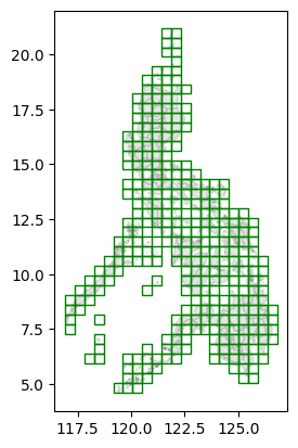
grid_gdf.describe()| x | y | |
|---|---|---|
| count | 323.000000 | 323.000000 |
| mean | 11.773994 | 15.018576 |
| std | 4.861594 | 8.791210 |
| min | 0.000000 | 0.000000 |
| 25% | 8.000000 | 8.000000 |
| 50% | 11.000000 | 14.000000 |
| 75% | 16.000000 | 21.000000 |
| max | 21.000000 | 37.000000 |
grid_gdf.head(3)| x | y | geometry | |
|---|---|---|---|
| 0 | 3 | 3 | POLYGON ((118.27581 5.92871, 118.72497 5.92871... |
| 1 | 2 | 3 | POLYGON ((117.82665 5.92871, 118.27581 5.92871... |
| 2 | 3 | 4 | POLYGON ((118.27581 6.37528, 118.72497 6.37528... |
grid_gdf.dtypesx int64
y int64
geometry geometry
dtype: objectSpatial join with highest intersection
get_highest_intersection
def get_highest_intersection(
    gdf1:GeoDataFrame, # gdf1 will be the basis of output geometry
    gdf2:GeoDataFrame, # gdf2 data will all be included during intersection
    proj_crs:str, # metric CRS (e.g., Philippines uses EPSG:32651)
)->GeoDataFrame:
Gets the intersection based on the largest area joined
get_highest_intersection(grid_gdf, admin_bounds_gdf, "EPSG:32651")| geometry | x | y | shapeName | shapeISO | shapeID | shapeGroup | shapeType | |
|---|---|---|---|---|---|---|---|---|
| 0 | POLYGON ((118.27581 5.92871, 118.72497 5.92871... | 3 | 3 | Tawi-Tawi | None | PHL-ADM2-3_0_0-B77 | PHL | ADM2 |
| 1 | POLYGON ((117.82665 5.92871, 118.27581 5.92871... | 2 | 3 | Tawi-Tawi | None | PHL-ADM2-3_0_0-B77 | PHL | ADM2 |
| 2 | POLYGON ((118.27581 6.37528, 118.72497 6.37528... | 3 | 4 | Tawi-Tawi | None | PHL-ADM2-3_0_0-B77 | PHL | ADM2 |
| 3 | POLYGON ((118.27581 6.82146, 118.72497 6.82146... | 3 | 5 | Tawi-Tawi | None | PHL-ADM2-3_0_0-B77 | PHL | ADM2 |
| 4 | POLYGON ((116.92834 7.26723, 117.37749 7.26723... | 0 | 6 | Palawan | None | PHL-ADM2-3_0_0-B59 | PHL | ADM2 |
| ... | ... | ... | ... | ... | ... | ... | ... | ... |
| 318 | POLYGON ((125.46233 5.03451, 125.91149 5.03451... | 19 | 1 | Davao del Sur | None | PHL-ADM2-3_0_0-B28 | PHL | ADM2 |
| 319 | POLYGON ((125.46233 9.93163, 125.91149 9.93163... | 19 | 12 | Dinagat Islands | None | PHL-ADM2-3_0_0-B30 | PHL | ADM2 |
| 320 | POLYGON ((125.46233 10.37375, 125.91149 10.373... | 19 | 13 | Eastern Samar | None | PHL-ADM2-3_0_0-B31 | PHL | ADM2 |
| 321 | POLYGON ((125.91149 9.93163, 126.36065 9.93163... | 20 | 12 | Surigao del Norte | None | PHL-ADM2-3_0_0-B74 | PHL | ADM2 |
| 322 | POLYGON ((125.91149 10.37375, 126.36065 10.373... | 20 | 13 | Eastern Samar | None | PHL-ADM2-3_0_0-B31 | PHL | ADM2 |
323 rows × 8 columns
Check plot of output
output = get_highest_intersection(grid_gdf, admin_bounds_gdf, "EPSG:32651")output.plot()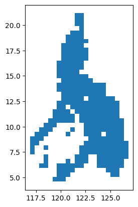
# output.explore()